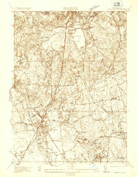
1936 Map of Mansfield
USGS Topo · Published 1936About this map
The Mansfield town center serves as a major rail junction in 1936, where the New York New Haven and Hartford RR lines intersect to move passengers and goods through Norfolk and Bristol Counties. This survey illustrates an era of transition, balancing the industrial footprints of Furnace Village and local cranberry cultivation at the Fuller-Hammond Cranberry Reservoir with the seasonal resort character of Massapoag Lake.
Find a feature on this map
89 named features on this map. Tap any name to fly to it.
Don’t see what you’re looking for? This feature index may not catch every label — zoom into the map to look around manually.
Map Details
Editions of this 1936 Mansfield Map
This is the sole edition of this map. No revisions or reprints were ever made.
Other maps of this area

1885 · Taunton
USGS Topo · 1:62,500

1886 · Dedham
USGS Topo · 1:62,500

1887 · Franklin
USGS Topo · 1:62,500

1887 · Providence
USGS Topo · 1:62,500

1888 · Taunton
USGS Topo · 1:62,500

1889 · Providence
USGS Topo · 1:62,500

1889 · Franklin
USGS Topo · 1:62,500

1893 · Taunton
USGS Topo · 1:62,500

1893 · Franklin
USGS Topo · 1:62,500

1894 · Dedham
USGS Topo · 1:62,500