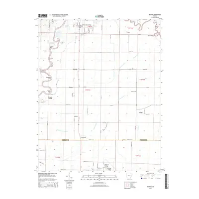
2014 Map of Manson
USGS Topo · Published 2014About this map
The Black River meanders through this portion of northeast Arkansas, defining the landscape with its intricate series of oxbows and river bends such as Horseshoe Lake, Stacy Bend, and Hoover Bend. The map illustrates the rural transition between the river's floodplains and the established communities of Pocahontas and Walnut Ridge, which serve as anchors at the northern and southern edges of the quadrangle. A network of drainage ditches and laterals, including Cypress Lateral and Tupelo Ditch, reveals the region's managed agricultural character and the engineering required to maintain the low-lying plains.
Find a feature on this map
96 named features on this map. Tap any name to fly to it.
Don’t see what you’re looking for? This feature index may not catch every label — zoom into the map to look around manually.
Map Details
Editions of this 2014 Manson Map
This is the sole edition of this map. No revisions or reprints were ever made.
Other maps of this area

1932 · Walnut Ridge
USGS Topo · 1:62,500

1934 · Powhatan
USGS Topo · 1:62,500

1935 · Powhatan
USGS Topo · 1:62,500

1935 · Reyno
USGS Topo · 1:62,500

1935 · Walnut Ridge
USGS Topo · 1:62,500

1957 · Poplar Bluff
USGS Topo · 1:250,000

1959 · Poplar Bluff
USGS Topo · 1:250,000

1960 · Poplar Bluff
USGS Topo · 1:250,000
1965 · Walnut Ridge SE
USGS Topo · 1:24,000
1965 · O'Kean
USGS Topo · 1:24,000