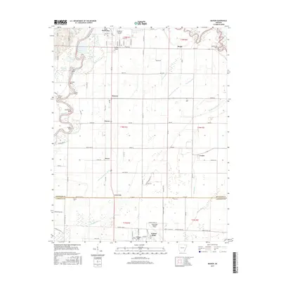
2017 Map of Manson
USGS Topo · Published 2017About this map
The Black River winds through the western edge of this landscape, defining the border between Randolph and Lawrence counties with a series of dramatic loops including Inman Bend, Stacy Bend, and Hoover Bend. This alluvial plain is a complex network of oxbow lakes and drainage features such as Horseshoe Lake, Dishman Lake, and the Little Running Water Ditch, illustrating the managed hydrology of the Arkansas Delta. Small agricultural settlements like Manson, Shannon, and Lesterville dot the interior, connected by a grid of rural roads such as Manson Rd and Old Co Rd. To the south, the transition toward College City and the northern outskirts of Walnut Ridge is marked by the presence of Mount Zion Ch and the Walnut Ridge Regional Airport, while the northern portion is anchored by East Pocahontas and the Pocahontas Municipal Airport.
Find a feature on this map
98 named features on this map. Tap any name to fly to it.
Don’t see what you’re looking for? This feature index may not catch every label — zoom into the map to look around manually.
Map Details
Editions of this 2017 Manson Map
This is the sole edition of this map. No revisions or reprints were ever made.
Other maps of this area

1932 · Walnut Ridge
USGS Topo · 1:62,500

1934 · Powhatan
USGS Topo · 1:62,500

1935 · Powhatan
USGS Topo · 1:62,500

1935 · Reyno
USGS Topo · 1:62,500

1935 · Walnut Ridge
USGS Topo · 1:62,500

1957 · Poplar Bluff
USGS Topo · 1:250,000

1959 · Poplar Bluff
USGS Topo · 1:250,000

1960 · Poplar Bluff
USGS Topo · 1:250,000
1965 · Walnut Ridge SE
USGS Topo · 1:24,000
1965 · O'Kean
USGS Topo · 1:24,000