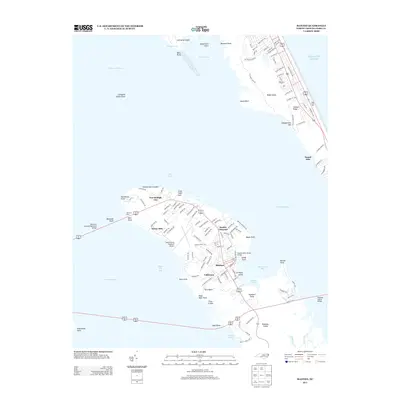
2013 Map of Manteo
USGS Topo · Published 2013About this map
Roanoke Island serves as the focal point of this coastal survey, positioned between the Croatan Sound and Roanoke Sound. The town of Manteo occupies the eastern shore, centered around the sheltered waters of Shallowbag Bay. To the north, the site of Fort Raleigh City and the Elizabethan Gardens reflect the area's deep colonial associations, while the presence of the Dare County Regional Airport and the sprawling residential networks in Sunny Side and Mother Vineyard indicate significant modern development. Across the water on Bodie Island, the prominent elevation of Jockeys Ridge stands between the sound and the Atlantic Ocean. The geography is defined by a complex network of points and shoals, from Weir Point near the Old Ferry Dock to the southern reaches of Skyco at Ashbee Harbor, illustrating the island's dependence on its maritime connections and the William B Umstead Memorial Bridge.
Find a feature on this map
138 named features on this map. Tap any name to fly to it.
Don’t see what you’re looking for? This feature index may not catch every label — zoom into the map to look around manually.
Map Details
Editions of this 2013 Manteo Map
This is the sole edition of this map. No revisions or reprints were ever made.
Other maps of this area

1940 · Kitty Hawk
USGS Topo · 1:62,500

1940 · Powells Point
USGS Topo · 1:62,500

1943 · Roanoke Island
USGS Topo · 1:125,000

1946 · Eastville
USGS Topo · 1:250,000

1946 · Currituck Sound
USGS Topo · 1:250,000

1953 · Wanchese
USGS Topo · 1:24,000

1953 · Roanoke Island NE
USGS Topo · 1:24,000

1953 · Manteo
USGS Topo · 1:24,000

1953 · East Lake SE
USGS Topo · 1:24,000

1953 · Manns Harbor
USGS Topo · 1:24,000