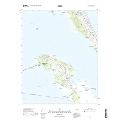
2019 Map of Manteo
USGS Topo · Published 2019About this map
Roanoke Island anchors this coastal survey, serving as a hub of early American memory and modern maritime life. The northern end of the island is dominated by the Fort Raleigh National Historic Site and the Alligator River National Wildlife Refuge, preserving a landscape of dense maritime forests and wetlands near Fort Raleigh City. To the south, the county seat of Manteo sits along the protected waters of Shallowbag Bay, while small communities like Mother Vineyard and California reflect the long-standing residential character of the island’s interior. Across the Roanoke Sound, the barrier islands show the dense residential development of Kill Devil Hills and Nags Head, where the massive sand dunes of Jockeys Ridge stand between the sound and the Atlantic Ocean. The map traces a complex network of causeways and bridges linking these outer banks to the mainland via Colington Island.
Find a feature on this map
114 named features on this map. Tap any name to fly to it.
Don’t see what you’re looking for? This feature index may not catch every label — zoom into the map to look around manually.
Map Details
Editions of this 2019 Manteo Map
This is the sole edition of this map. No revisions or reprints were ever made.
Other maps of this area

1940 · Kitty Hawk
USGS Topo · 1:62,500

1940 · Powells Point
USGS Topo · 1:62,500

1943 · Roanoke Island
USGS Topo · 1:125,000

1946 · Eastville
USGS Topo · 1:250,000

1946 · Currituck Sound
USGS Topo · 1:250,000

1953 · Wanchese
USGS Topo · 1:24,000

1953 · Roanoke Island NE
USGS Topo · 1:24,000

1953 · Manteo
USGS Topo · 1:24,000

1953 · East Lake SE
USGS Topo · 1:24,000

1953 · Manns Harbor
USGS Topo · 1:24,000