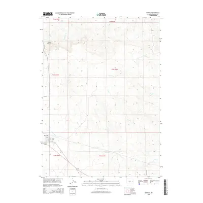
2015 Map of Manville
USGS Topo · Published 2015About this map
Manville occupies the southwestern corner of this Niobrara County survey, centered around a traditional grid of streets including 3rd St, 6th St, and 5th Ave. The surrounding landscape is defined by the high plains drainage system, where the Niobrara River flows eastward across the southern section of the map. To the north, the terrain rises into the Seventy-Seven Hills, a series of prominent topographic features that overlook a network of seasonal watercourses such as Bergreen Cr, Quinn Cr, and Duck Cr. Local history is anchored at the Dellview Cem located just east of the main settlement along highway 270. The map also traces more remote landmarks like Kelly Spring and N Fork Wyatte Cr, reflecting the vital importance of water sources in this dry Wyoming ranching environment during the early 21st century.
Find a feature on this map
26 named features on this map. Tap any name to fly to it.
Don’t see what you’re looking for? This feature index may not catch every label — zoom into the map to look around manually.
Map Details
Editions of this 2015 Manville Map
This is the sole edition of this map. No revisions or reprints were ever made.
Other maps of this area

1954 · Torrington
USGS Topo · 1:250,000

1958 · Torrington
USGS Topo · 1:250,000

1974 · Lone Tree Hill
USGS Topo · 1:24,000

1974 · Silver Springs
USGS Topo · 1:24,000
1974 · Reynolds Spring
USGS Topo · 1:24,000

1981 · Lusk
USGS Topo · 1:24,000

1981 · Manville
USGS Topo · 1:24,000
1981 · Hat Rock
USGS Topo · 1:24,000

1981 · Bills Creek
USGS Topo · 1:24,000
1981 · Manville NE
USGS Topo · 1:24,000