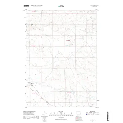
2017 Map of Manville
USGS Topo · Published 2017About this map
The town of Manville sits as a central hub in this high-plains landscape, where the local street grid is defined by numbered avenues like 5th Ave and 8th Ave. The terrain is deeply inscribed by a network of drainage systems, most notably the Niobrara River which flows across the southern portion of the quadrangle. Several significant tributaries, including Quinn Cr and Bergreen Cr, carve through the rolling hills, providing critical water sources in an otherwise arid environment.
Find a feature on this map
22 named features on this map. Tap any name to fly to it.
Don’t see what you’re looking for? This feature index may not catch every label — zoom into the map to look around manually.
Map Details
Editions of this 2017 Manville Map
This is the sole edition of this map. No revisions or reprints were ever made.
Other maps of this area

1954 · Torrington
USGS Topo · 1:250,000

1958 · Torrington
USGS Topo · 1:250,000

1974 · Lone Tree Hill
USGS Topo · 1:24,000

1974 · Silver Springs
USGS Topo · 1:24,000
1974 · Reynolds Spring
USGS Topo · 1:24,000

1981 · Lusk
USGS Topo · 1:24,000

1981 · Manville
USGS Topo · 1:24,000
1981 · Hat Rock
USGS Topo · 1:24,000

1981 · Bills Creek
USGS Topo · 1:24,000
1981 · Manville NE
USGS Topo · 1:24,000