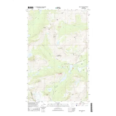
2017 Map of Many Glacier
USGS Topo · Published 2017About this map
Many Glacier sits at the heart of this high-altitude landscape, where the seasonal movement of hikers and stock is traced through a complex network of trails and mountain passes. The map documents the intricate hydrology of the Lewis Range, dominated by the Swiftcurrent Glacier and the Grinnell Glacier, which feed a chain of alpine waters including Iceberg Lake, Swiftcurrent Lake, and Lake Josephine. A significant feat of early wilderness engineering is visible at Ptarmigan Tunnel, providing passage through the formidable Ptarmigan Wall.
Find a feature on this map
81 named features on this map. Tap any name to fly to it.
Don’t see what you’re looking for? This feature index may not catch every label — zoom into the map to look around manually.
Map Details
Editions of this 2017 Many Glacier Map
This is the sole edition of this map. No revisions or reprints were ever made.
Other maps of this area

1904 · Chief Mountain
USGS Topo · 1:125,000

1938 · Chief Mountain
USGS Topo · 1:125,000

1960 · Cut Bank
USGS Topo · 1:250,000

1963 · Cut Bank
USGS Topo · 1:250,000

1964 · Cut Bank
USGS Topo · 1:250,000

1968 · Ahern Pass
USGS Topo · 1:24,000
1968 · Mount Cannon
USGS Topo · 1:24,000

1968 · Gable Mountain
USGS Topo · 1:24,000
1968 · Mount Cleveland
USGS Topo · 1:24,000
1968 · Logan Pass
USGS Topo · 1:24,000