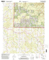
1997 Map of Many Springs
USGS Topo · Published 2000About this map
Couch and Norman anchor the southern portion of this landscape, situated at a time when the rural infrastructure of Oregon County remained focused on small community centers and dispersed agricultural tracts. The terrain is deeply incised by a network of drainage basins such as Rough Hollow and Blankenship Hollow, many of which feed into larger water systems like Hurricane Creek. A significant portion of the northern half is managed as part of the Mark Twain National Forest, including the protected Eleven Point Wild and Scenic River corridor. The map reveals a high density of country churches and family-named cemeteries, including Allen Chapel, Nebo Church, and the Hollis Cemetery, reflecting a long-standing pattern of upland settlement. The presence of Many Springs and the Braswell Lookout suggest a landscape valued for its natural resources and conservation, while a private Landing Strip and various gravel pits indicate the area's modern utilitarian uses.
Find a feature on this map
49 named features on this map. Tap any name to fly to it.
Don’t see what you’re looking for? This feature index may not catch every label — zoom into the map to look around manually.
Map Details
Editions of this 1997 Many Springs Map
This is the sole edition of this map. No revisions or reprints were ever made.
Other maps of this area

1931 · Bandyville
USGS Topo · 1:48,000

1941 · Gatewood
USGS Topo · 1:62,500

1944 · Van Buren
USGS Topo · 1:62,500

1944 · Couch
USGS Topo · 1:62,500

1944 · Birch Tree
USGS Topo · 1:62,500

1945 · Gatewood
USGS Topo · 1:62,500

1946 · Couch
USGS Topo · 1:62,500

1946 · Van Buren
USGS Topo · 1:62,500

1948 · Birch Tree
USGS Topo · 1:62,500

1957 · Poplar Bluff
USGS Topo · 1:250,000