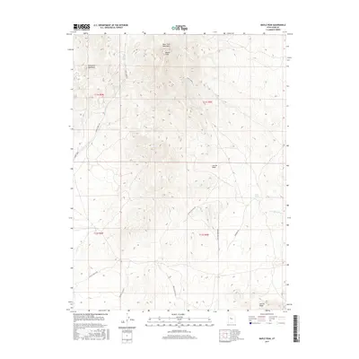
2017 Map of Maple Peak
USGS Topo · Published 2017About this map
Maple Peak rises as the central landmark of this high-elevation landscape in the West Tintic Mountains, where the eastern slopes of the Sheeprock Mountains meet the high desert of Juab County. This 2017 survey shows a region defined by its drainage patterns and seasonal water sources, such as the Cherry Cr Reservoir and the Cherry Creek drainage to the west, and the aptly named Mud Spring to the east. The terrain is crisscrossed by established tracks including Cherry Creek Rd and Jericho Callao Rd, which serve as vital connectors in this open rangeland. To the south, the level expanse of Motor Cycle Flat provides a contrast to the dissected geography of Jericho Wash and Chambers Wash. This map is an essential reference for understanding the modern topographic state of these mountain ranges and the cattle-grazing infrastructure that continues to shape the local geography.
Find a feature on this map
20 named features on this map. Tap any name to fly to it.
Don’t see what you’re looking for? This feature index may not catch every label — zoom into the map to look around manually.
Map Details
Editions of this 2017 Maple Peak Map
This is the sole edition of this map. No revisions or reprints were ever made.
Other maps of this area

1885 · Sevier Desert
USGS Topo · 1:250,000

1953 · Delta
USGS Topo · 1:250,000

1954 · Mc Intyre
USGS Topo · 1:24,000

1954 · Tintic Junction
USGS Topo · 1:24,000

1958 · Delta
USGS Topo · 1:250,000

1962 · Delta
USGS Topo · 1:250,000

1962 · Lynndyl
USGS Topo · 1:62,500

1963 · Maple Peak
USGS Topo · 1:24,000
1963 · Sabie Mountain
USGS Topo · 1:24,000

1963 · Dutch Peak
USGS Topo · 1:24,000