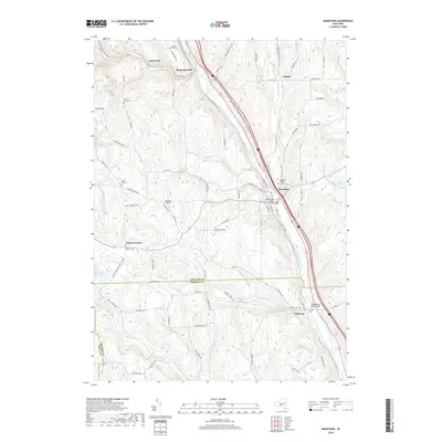
2019 Map of Marathon
USGS Topo · Published 2019About this map
The Tioughnioga River corridor anchors this section of Central New York, where the river valley carves a path through the high ground of southern Cortland and northern Broome counties. Small settlements like Marathon and Messengerville are positioned along this vital waterway, while upland hamlets such as Hunts Corners and Galatia dot the surrounding ridges. The landscape is heavily marked by local family and community history, evidenced by numerous burial grounds including Snyder Hill Cem, Quail Hill Cem, and the Marathon Village Cem.
Find a feature on this map
88 named features on this map. Tap any name to fly to it.
Don’t see what you’re looking for? This feature index may not catch every label — zoom into the map to look around manually.
Map Details
Editions of this 2019 Marathon Map
This is the sole edition of this map. No revisions or reprints were ever made.
Other maps of this area
1903 · Cortland
USGS Topo · 1:62,500
1903 · Harford
USGS Topo · 1:62,500
1904 · Greene
USGS Topo · 1:62,500
1904 · Pitcher
USGS Topo · 1:62,500
1906 · Catatonk
USGS Topo · 1:125,000
1943 · Cincinnatus
USGS Topo · 1:24,000
1944 · Cortland
USGS Topo · 1:31,680
1944 · Mc Graw
USGS Topo · 1:31,680
1944 · Cincinnatus
USGS Topo · 1:31,680
1948 · Binghamton
USGS Topo · 1:250,000