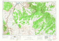
1956 Map of Marble Canyon
USGS Topo · Published 1968About this map
Tuba City and the neighboring community of Moenkopi serve as central hubs in this mid-century portrait of Northern Arizona. This period was defined by the massive engineering project at the Glen Canyon Dam Site and the emergence of the nuclear age, evidenced by the Uranium mill located near the southern edge of the Kaibito Plateau. The landscape is dominated by the massive tectonic uplift of the Echo Cliffs and the deep carving of the Colorado River through Marble Canyon. Cultural history is prominently noted through the preservation of ancestral sites like Keet Seel Ruin and Betatakin Ruin within the Navajo National Monument, while contemporary commerce is represented by outposts like the Cow Springs Trading Post. The map reveals a high-desert territory where ancient geography and modern infrastructure, including Navajo Bridge, meet.
Find a feature on this map
139 named features on this map. Tap any name to fly to it.
Don’t see what you’re looking for? This feature index may not catch every label — zoom into the map to look around manually.
Map Details
Editions of this 1956 Marble Canyon Map
4 editions found

Other maps of this area

1883 · Marsh Pass
USGS Topo · 1:250,000

1883 · Tusayan
USGS Topo · 1:250,000

1886 · Kanab
USGS Topo · 1:250,000

1886 · Tusayan
USGS Topo · 1:250,000

1886 · Fort Defiance
USGS Topo · 1:250,000

1886 · Escalante
USGS Topo · 1:250,000

1886 · Henry Mountains
USGS Topo · 1:250,000

1886 · San Francisco Mtns
USGS Topo · 1:250,000

1886 · Abajo
USGS Topo · 1:250,000

1886 · Chino
USGS Topo · 1:250,000