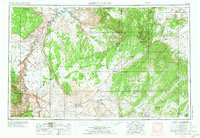
1956 Map of Marble Canyon
USGS Topo · Published 1973About this map
The Colorado River carves through the heart of this landscape, marking the dramatic transition from the Glen Canyon National Recreation Area into the northern reaches of Grand Canyon National Park. Revised in 1970, the map documents the arrival of the Glen Canyon Dam and the rising waters of Lake Powell, contrasting these modern engineering feats against ancient landmarks like Lees Ferry and the Navajo Bridge.
Find a feature on this map
145 named features on this map. Tap any name to fly to it.
Don’t see what you’re looking for? This feature index may not catch every label — zoom into the map to look around manually.
Map Details
Editions of this 1956 Marble Canyon Map
4 editions found

Other maps of this area

1883 · Marsh Pass
USGS Topo · 1:250,000

1883 · Tusayan
USGS Topo · 1:250,000

1886 · Kanab
USGS Topo · 1:250,000

1886 · Tusayan
USGS Topo · 1:250,000

1886 · Fort Defiance
USGS Topo · 1:250,000

1886 · Escalante
USGS Topo · 1:250,000

1886 · Henry Mountains
USGS Topo · 1:250,000

1886 · San Francisco Mtns
USGS Topo · 1:250,000

1886 · Abajo
USGS Topo · 1:250,000

1886 · Chino
USGS Topo · 1:250,000