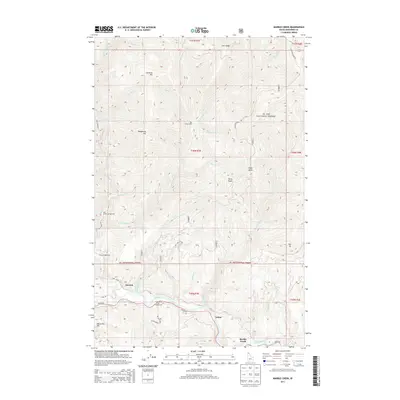
2013 Map of Marble Creek
USGS Topo · Published 2013About this map
The Saint Joe River valley defines the southern portion of this Idaho landscape, where the settlements of Herrick, Erlmo, and Marble Creek are situated along the water's edge. This area, managed as part of the St. Joe National Forest, reveals a history of land use focused on recreation and forestry. Multiple sites like CCC Campground, Big Creek Campground, and Huckleberry Flat Campground indicate the importance of the river corridor for public access. North of the river, the terrain rises sharply toward prominent points such as Sheep Butte and Drive Point.
Find a feature on this map
42 named features on this map. Tap any name to fly to it.
Don’t see what you’re looking for? This feature index may not catch every label — zoom into the map to look around manually.
Map Details
Editions of this 2013 Marble Creek Map
This is the sole edition of this map. No revisions or reprints were ever made.
Other maps of this area

1914 · Avery
USGS Topo · 1:125,000

1917 · Avery
USGS Topo · 1:125,000

1955 · Spokane
USGS Topo · 1:250,000

1956 · Wallace
USGS Topo · 1:250,000

1957 · Wallace
USGS Topo · 1:62,500

1957 · Calder
USGS Topo · 1:62,500

1958 · Spokane
USGS Topo · 1:250,000

1960 · Wallace
USGS Topo · 1:250,000

1969 · Marble Mountain
USGS Topo · 1:24,000
1969 · Hoyt Mountain
USGS Topo · 1:24,000