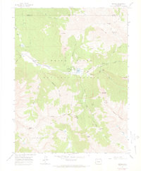
1960 Map of Marble
USGS Topo · Published 1966About this map
The town of Marble sits at the heart of this high-elevation survey, reflecting a landscape defined by industrial extraction and the burgeoning outdoor recreation movement of the mid-20th century. While the settlement is famously associated with the white stone used in national monuments, this 1960 field-checked map documents the active presence of the Yule Quarry and Strauss Quarry south of the townsite. The transition toward educational and wilderness use is marked by the Colorado Outward Bound Sch and several remote ranching outposts like Bair Ranch and Snowshoe Ranch. High-altitude mining history is further evidenced by the Skyline Mine near Whitehouse Mountain and the Genter Mine on Rapid Creek. The terrain is dominated by the Crystal River corridor, with narrow mountain passes like Anthracite Pass connecting the White River National Forest to the Gunnison National Forest. Genealogists will find the Marble Cem and an isolated Grave near the Landing Strip, underscoring the town's historical isolation.
Find a feature on this map
58 named features on this map. Tap any name to fly to it.
Don’t see what you’re looking for? This feature index may not catch every label — zoom into the map to look around manually.
Map Details
Editions of this 1960 Marble Map
5 editions found

Other maps of this area

1888 · Anthracite
USGS Topo · 1:62,500

1889 · Anthracite
USGS Topo · 1:62,500

1893 · Anthracite
USGS Topo · 1:62,500

1894 · Anthracite
USGS Topo · 1:62,500

1938 · Mt. Gunnison
USGS Topo · 1:48,000

1945 · Mount Gunnison
USGS Topo · 1:62,500

1956 · Montrose
USGS Topo · 1:250,000

1957 · Leadville
USGS Topo · 1:250,000

1959 · Leadville
USGS Topo · 1:250,000

1959 · Montrose
USGS Topo · 1:250,000