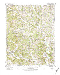
1933 Map of Marble Hill
USGS Topo · Published 1984About this map
The rolling landscape of Bollinger County and Cape Girardeau County is captured here as it appeared in the early 1930s, defined by the winding Whitewater River and its numerous tributaries. The neighboring settlements of Marble Hill and Lutesville serve as central hubs for a rural network of family-named schools and churches. This era shows a community deeply rooted in its local geography, with institutions like Bricks Chapel and Trinity Ch providing social anchors for the surrounding farms.
Find a feature on this map
72 named features on this map. Tap any name to fly to it.
Don’t see what you’re looking for? This feature index may not catch every label — zoom into the map to look around manually.
Map Details
Editions of this 1933 Marble Hill Map
3 editions found
Other maps of this area

1910 · Higdon
USGS Topo · 1:62,500

1918 · Altenburg
USGS Topo · 1:62,500

1922 · Cape Girardeau
USGS Topo · 1:62,500

1923 · Perryville
USGS Topo · 1:62,500

1924 · Cape Girardeau
USGS Topo · 1:62,500

1924 · Perryville
USGS Topo · 1:62,500

1925 · Altenburg
USGS Topo · 1:62,500

1933 · Marble Hill
USGS Topo · 1:62,500

1933 · Marquand
USGS Topo · 1:62,500

1934 · Morley
USGS Topo · 1:62,500