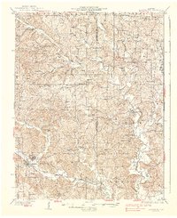
1937 Map of Marble Hill
USGS Topo · Published 1937About this map
Marble Hill and the adjacent town of Lutesville serve as the primary hubs in this 1930s landscape, positioned where the Missouri Pacific railroad crosses Crooked Creek. The region is defined by a dense network of rural infrastructure, with numerous family-named landmarks and community institutions scattered across townships like Lorance and Kinder. Notable educational sites such as Thornburgh Sch and Hickory Grove Sch appear alongside traditional gathering places like Becks Chapel and Trinity Ch. The map reveals a deeply established agrarian society where local geography is marked by small settlements like Scopus and Laflin, and many small burial grounds including Pulliam Cem and Mcguire Cem. The drainage patterns of the Whitewater River and its many tributaries, such as Drunken Creek and Panther Creek, dictated the placement of roads and the early development of this portion of Bollinger County.
Find a feature on this map
72 named features on this map. Tap any name to fly to it.
Don’t see what you’re looking for? This feature index may not catch every label — zoom into the map to look around manually.
Map Details
Editions of this 1937 Marble Hill Map
2 editions found

Other maps of this area

1910 · Higdon
USGS Topo · 1:62,500

1918 · Altenburg
USGS Topo · 1:62,500

1922 · Cape Girardeau
USGS Topo · 1:62,500

1923 · Perryville
USGS Topo · 1:62,500

1924 · Cape Girardeau
USGS Topo · 1:62,500

1924 · Perryville
USGS Topo · 1:62,500

1925 · Altenburg
USGS Topo · 1:62,500

1933 · Marble Hill
USGS Topo · 1:62,500

1933 · Marquand
USGS Topo · 1:62,500

1934 · Morley
USGS Topo · 1:62,500