
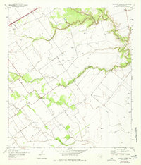
1952 Map of Marcado Creek
USGS Topo · Published 1953About this map
The coastal plains of Victoria County are defined by a complex network of waterways and early petroleum infrastructure in this mid-century survey. Marcado Creek winds centrally through the landscape, joined by tributaries like Casa Blanca Creek and Aquila Creek. The presence of several Oil Wells and Gas Wells indicates the region's industrial shift toward energy production, while extensive Levee systems and a Spoil Bank reveal significant human modification of the drainage patterns.
Find a feature on this map
16 named features on this map. Tap any name to fly to it.
Don’t see what you’re looking for? This feature index may not catch every label — zoom into the map to look around manually.
Map Details
Editions of this 1952 Marcado Creek Map
2 editions found
Other maps of this area

1951 · Bloomington
USGS Topo · 1:24,000

1951 · Inez NW
USGS Topo · 1:24,000

1951 · Inez
USGS Topo · 1:24,000

1952 · Edna
USGS Topo · 1:24,000

1952 · Kamey
USGS Topo · 1:24,000

1952 · La Salle
USGS Topo · 1:24,000

1952 · Placedo
USGS Topo · 1:24,000

1952 · Victoria East
USGS Topo · 1:24,000

1953 · Beeville
USGS Topo · 1:250,000

1956 · Beeville
USGS Topo · 1:250,000