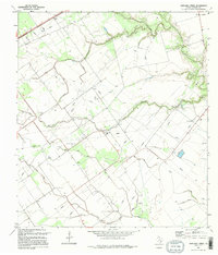
1995 Map of Marcado Creek
USGS Topo · Published 1995About this map
Marcado Creek meanders through the coastal plains of Victoria County, defining a landscape of agricultural drainage and early petroleum extraction. This mid-1990s survey illustrates a region where water management is paramount, featuring extensive Levee systems and man-made Spoil Bank formations that flank the local waterways. The map preserves the locations of local landmarks such as the Wood Sch and nearby Wood High Cem, which along with the Shillerville Cem farther south, offer critical data points for genealogists tracing family histories in these rural settlements. The terrain is dotted with numerous Oil Wells, Gas Wells, and a Pumping Sta, reflecting the industrial footprint on the land. Five distinct water bodies, including Garcitas Creek and Arroyo Palo Alto, create a complex riparian network across the low-lying Texas prairie.
Find a feature on this map
14 named features on this map. Tap any name to fly to it.
Don’t see what you’re looking for? This feature index may not catch every label — zoom into the map to look around manually.
Map Details
Editions of this 1995 Marcado Creek Map
This is the sole edition of this map. No revisions or reprints were ever made.
Other maps of this area

1951 · Bloomington
USGS Topo · 1:24,000

1951 · Inez NW
USGS Topo · 1:24,000

1951 · Inez
USGS Topo · 1:24,000

1952 · Edna
USGS Topo · 1:24,000

1952 · Kamey
USGS Topo · 1:24,000

1952 · La Salle
USGS Topo · 1:24,000

1952 · Marcado Creek
USGS Topo · 1:24,000

1952 · Placedo
USGS Topo · 1:24,000

1952 · Victoria East
USGS Topo · 1:24,000

1953 · Beeville
USGS Topo · 1:250,000