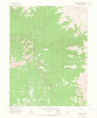
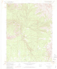
1961 Map of Marcellina Mountain
USGS Topo · Published 1964About this map
Marcellina Mtn and the soaring peaks of the Ruby Range dominate this high-elevation corner of the Gunnison National Forest. Photogrammetric methods from 1958 aerial surveys illustrate a complex network of glacial cirques including Swan Basin, Buck Basin, and Gold Basin. The presence of the West Side Cow Camp and specialized routes like the Munsey Ruby Stock Driveway highlight the region's historic use for seasonal livestock grazing. Steep drainages such as Dark Canyon Creek and Ruby Anthracite Creek carve through the landscape, while dramatic natural landmarks like the Devils Stairway and The Dyke underscore the geologic intensity of the area. This survey documents the transition from high-country ranching infrastructure to pure wilderness management within the White River National Forest boundaries.
Find a feature on this map
36 named features on this map. Tap any name to fly to it.
Don’t see what you’re looking for? This feature index may not catch every label — zoom into the map to look around manually.
Map Details
Editions of this 1961 Marcellina Mountain Map
5 editions found
Other maps of this area

1888 · Anthracite
USGS Topo · 1:62,500

1889 · Anthracite
USGS Topo · 1:62,500

1893 · Anthracite
USGS Topo · 1:62,500

1894 · Anthracite
USGS Topo · 1:62,500

1938 · Mt. Gunnison
USGS Topo · 1:48,000

1945 · Mount Gunnison
USGS Topo · 1:62,500

1956 · Montrose
USGS Topo · 1:250,000

1957 · Leadville
USGS Topo · 1:250,000

1959 · Leadville
USGS Topo · 1:250,000

1959 · Montrose
USGS Topo · 1:250,000