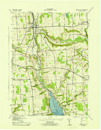
1943 Map of Marcellus
USGS Topo · Published 1943About this map
Marcellus and the surrounding Onondaga County countryside are defined by a network of historic thoroughfares, including the Seneca Turnpike and the Cherry Valley Turnpike. This 1943 survey, conducted by the Tennessee Valley Authority for the War Department, illustrates a landscape where small hamlets like Navarino, Marietta, and Clintonville were connected by steep-walled depressions like Pumpkin Hollow. The topography is particularly striking around the northern reach of Otisco Lake, where the shoreline transitions into The Narrows. Numerous family-named landmarks and rural schoolhouses, such as School No 8 and School No 4, reflect the era's local community structure. Genealogists will find exceptional value in the density of burial grounds throughout the townships, from St Francis Cem near the village center to remote plots like Burns Cem and Amber Cem overlooking the water.
Find a feature on this map
64 named features on this map. Tap any name to fly to it.
Don’t see what you’re looking for? This feature index may not catch every label — zoom into the map to look around manually.
Map Details
Editions of this 1943 Marcellus Map
This is the sole edition of this map. No revisions or reprints were ever made.
Other maps of this area

1895 · Syracuse
USGS Topo · 1:62,500

1898 · Syracuse
USGS Topo · 1:62,500

1899 · Skaneateles
USGS Topo · 1:62,500

1900 · Baldwinsville
USGS Topo · 1:62,500

1900 · Tully
USGS Topo · 1:62,500

1902 · Skaneateles
USGS Topo · 1:62,500

1939 · Syracuse West
USGS Topo · 1:24,000

1943 · South Onondaga
USGS Topo · 1:31,680

1943 · Jordan
USGS Topo · 1:31,680

1943 · Spafford
USGS Topo · 1:31,680