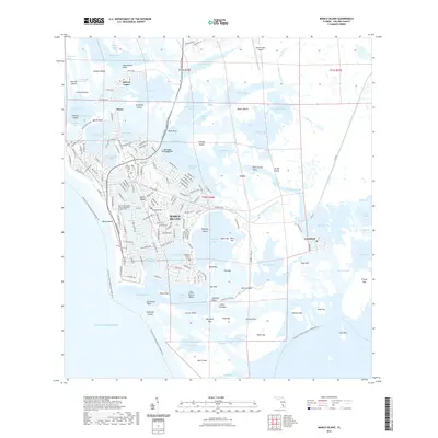
2021 Map of Marco Island
USGS Topo · Published 2021About this map
Marco Island is depicted in high detail during this twenty-first-century survey, revealing a landscape where complex water networks and modern residential development intersect. The map traces the dense street grids of Marco Beach and the distinctive northern enclave of the Isles of Capri, framed by the Gulf waters of Capri Pass and Big Marco Pass. Historical roots are evident at the Caxambas Pioneer Cem and the Marco Island Cem, pointing to the island's earlier settlements. To the south, the industrial history of the coast is marked by Clam Factory Shoal in Caxambas Bay, while the eastern portion of the sheet remains dominated by a vast labyrinth of mangroves and keys, including Big Key and Rookery Island. This survey captures the specialized infrastructure of the region, from the Marco Island Airport to the intricate network of canals like Smokehouse Creek and Factory Bay that define the modern waterfront lifestyle.
Find a feature on this map
192 named features on this map. Tap any name to fly to it.
Don’t see what you’re looking for? This feature index may not catch every label — zoom into the map to look around manually.
Map Details
Editions of this 2021 Marco Island Map
This is the sole edition of this map. No revisions or reprints were ever made.
Other maps of this area

1956 · Miami
USGS Topo · 1:250,000

1956 · West Palm Beach
USGS Topo · 1:250,000

1957 · West Palm Beach
USGS Topo · 1:250,000

1958 · West Palm Beach
USGS Topo · 1:250,000

1958 · Miami
USGS Topo · 1:250,000

1958 · Belle Meade
USGS Topo · 1:24,000

1958 · Naples South
USGS Topo · 1:24,000

1958 · Belle Meade SE
USGS Topo · 1:24,000

1973 · Cape Romano
USGS Topo · 1:24,000

1973 · Marco Island
USGS Topo · 1:24,000