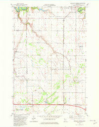
1982 Map of Marcoux Corners
USGS Topo · Published 1982About this map
The Red Lake River and Clearwater River converge in this section of northwestern Minnesota, anchoring the landscape near the town of Red Lake Falls. This early 1980s data highlights a region defined by its water management and agricultural infrastructure, from the straight lines of Judicial Ditch No 14 to the winding course of Kripple Creek. Genealogists and local historians can pinpoint Cyr Cem in the north and the settlement of Kertsonville in the southwest, while the rural character of the land is further evidenced by various Gravel Pits and the Red Lake Falls Municipal Airport. The Burlington Northern railroad runs north-south through Lake Pleasant, connecting the small hubs of Townhall and Marcoux Corners. Protected natural spaces like the Stipa State Wildlife Management Area represent the preserved wetlands typical of Red Lake and Polk counties.
Find a feature on this map
29 named features on this map. Tap any name to fly to it.
Don’t see what you’re looking for? This feature index may not catch every label — zoom into the map to look around manually.
Map Details
Editions of this 1982 Marcoux Corners Map
This is the sole edition of this map. No revisions or reprints were ever made.
Other maps of this area

1918 · Terrebonne
USGS Topo · 1:62,500

1918 · Red Lake Falls
USGS Topo · 1:62,500

1919 · Valley
USGS Topo · 1:62,500

1952 · Red Lake Falls
USGS Topo · 1:62,500

1952 · Grand Forks
USGS Topo · 1:250,000

1956 · Grand Forks
USGS Topo · 1:250,000
1964 · Plummer NW
USGS Topo · 1:24,000

1964 · Terrebonne
USGS Topo · 1:24,000

1965 · Dugdale
USGS Topo · 1:24,000

1965 · Harold
USGS Topo · 1:24,000