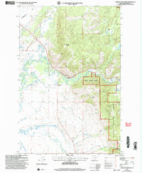
2001 Map of Marcum Mountain
USGS Topo · Published 2004About this map
Helena National Forest land dominates the eastern half of this terrain, where the slopes of Marcum Mountain and Trapper Mountain rise above the river valley. The landscape is defined by the winding course of the Blackfoot River, which transitions from the steep forest edge into the open expanses of Kleinschmidt Flat. This 2001 revision illustrates a complex water management system for ranching and agriculture, featuring the Helmville Canal, North Canal, and Lincoln Slough.
Find a feature on this map
28 named features on this map. Tap any name to fly to it.
Don’t see what you’re looking for? This feature index may not catch every label — zoom into the map to look around manually.
Map Details
Editions of this 2001 Marcum Mountain Map
This is the sole edition of this map. No revisions or reprints were ever made.
Other maps of this area

1889 · Helena
USGS Topo · 1:250,000

1893 · Helena
USGS Topo · 1:250,000

1899 · Helena
USGS Topo · 1:250,000

1902 · Ovando
USGS Topo · 1:125,000

1903 · Coopers Lake
USGS Topo · 1:125,000

1903 · Helena
USGS Topo · 1:250,000

1905 · Ovando
USGS Topo · 1:125,000

1919 · Drummond
USGS Topo · 1:125,000

1921 · Drummond
USGS Topo · 1:125,000

1947 · Butte
USGS Topo · 1:250,000