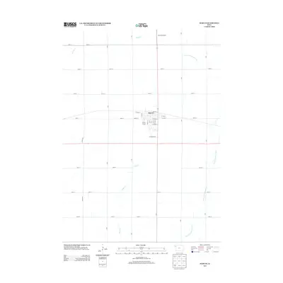
2013 Map of Marcus
USGS Topo · Published 2013About this map
Marcus serves as the central hub of this Cherokee County agricultural landscape, organized by a precise grid of rural routes such as 160th St and B Ave. The town's layout is defined by its relationship with the rail line, evidenced by Railroad St running parallel to the tracks through the heart of the community. Outside the residential blocks of N Linn St and S Beech St, the terrain is drained by a network of local waterways, including Whisky Cr to the north and Fiddle Cr to the south. The presence of Sand Field Airport north of town and Golf Course Rd to the south indicates the area's modern infrastructure and community development. To the east, the W Fork Little Sioux River meanders through the farmland, creating a distinct natural break in the otherwise systematic survey grid.
Find a feature on this map
41 named features on this map. Tap any name to fly to it.
Don’t see what you’re looking for? This feature index may not catch every label — zoom into the map to look around manually.
Map Details
Editions of this 2013 Marcus Map
This is the sole edition of this map. No revisions or reprints were ever made.
Other maps of this area

1954 · Fort Dodge
USGS Topo · 1:250,000

1957 · Fort Dodge
USGS Topo · 1:250,000

1958 · Fort Dodge
USGS Topo · 1:250,000

1969 · Cleghorn
USGS Topo · 1:24,000

1969 · Fielding
USGS Topo · 1:24,000
1969 · Granville West
USGS Topo · 1:24,000
1969 · Marcus
USGS Topo · 1:24,000
1969 · Granville East
USGS Topo · 1:24,000
1969 · Remsen
USGS Topo · 1:24,000
1969 · Kingsley NW
USGS Topo · 1:24,000