
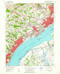
1953 Map of Marcus Hook
USGS Topo · Published 1956About this map
The industrial corridor along the Delaware River defines this 1953 revision, where the dense urban grid of Chester meets the heavy maritime infrastructure of Marcus Hook. This period shows a landscape shaped by massive petroleum storage and transport, evidenced by the extensive Tank Farm near Linwood and the significant rail presence of the Pennsylvania Railroad and Baltimore and Ohio Railroad. Across the river in New Jersey, the U S Military Reservation and sprawling marshlands around Oldmans Creek provide a stark contrast to the developed Pennsylvania shore.
Find a feature on this map
74 named features on this map. Tap any name to fly to it.
Don’t see what you’re looking for? This feature index may not catch every label — zoom into the map to look around manually.
Map Details
Editions of this 1953 Marcus Hook Map
2 editions found
Other maps of this area

1890 · Salem
USGS Topo · 1:62,500

1894 · Chester
USGS Topo · 1:62,500

1896 · Chester
USGS Topo · 1:62,500

1898 · Salem
USGS Topo · 1:62,500

1898 · Chester
USGS Topo · 1:62,500

1901 · Camden
USGS Topo · 1:125,000

1901 · West Chester
USGS Topo · 1:62,500

1904 · West Chester
USGS Topo · 1:62,500

1904 · Wilmington
USGS Topo · 1:62,500

1906 · Wilmington
USGS Topo · 1:62,500