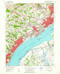
1953 Map of Marcus Hook
USGS Topo · Published 1964About this map
Industrial developments and river commerce along the Delaware River define this mid-century landscape at the meeting point of Pennsylvania, Delaware, and New Jersey. Heavy infrastructure for the Reading RR, Pennsylvania RR, and Baltimore and Ohio RR lines corridors through established riverside communities like Marcus Hook and Chester. The dense urban grid of Claymont and Upland stands in contrast to the marshy lowlands of the U S Military Reservation and Raccoon Island across the water in New Jersey. Local life is documented through numerous institutions, from the St Patricks Monastery near Holly Oak to various family-named schools such as Francis Green Sch. This survey also records the vital maritime presence of the U S Quarantine Sta and multiple shore-side markers that once guided traffic through the busy tri-state channel.
Find a feature on this map
78 named features on this map. Tap any name to fly to it.
Don’t see what you’re looking for? This feature index may not catch every label — zoom into the map to look around manually.
Map Details
Editions of this 1953 Marcus Hook Map
2 editions found

Other maps of this area

1890 · Salem
USGS Topo · 1:62,500

1894 · Chester
USGS Topo · 1:62,500

1896 · Chester
USGS Topo · 1:62,500

1898 · Salem
USGS Topo · 1:62,500

1898 · Chester
USGS Topo · 1:62,500

1901 · Camden
USGS Topo · 1:125,000

1901 · West Chester
USGS Topo · 1:62,500

1904 · West Chester
USGS Topo · 1:62,500

1904 · Wilmington
USGS Topo · 1:62,500

1906 · Wilmington
USGS Topo · 1:62,500