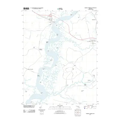
2011 Map of Mardela Springs
USGS Topo · Published 2011About this map
The Nanticoke River defines this Eastern Shore landscape, carving a wide path through the marshy terrain of Wicomico and Dorchester Counties. At its narrowest point on this map, the river is crossed by the town of Vienna, where the Vienna Post Office and Vienna Cemetery serve as central community landmarks. The wetlands are characterized by an intricate network of waterways like Barren Creek, Rewastico Creek, and Manumsco Creek, illustrating a classic tidewater geography where land and water are deeply integrated.
Find a feature on this map
81 named features on this map. Tap any name to fly to it.
Don’t see what you’re looking for? This feature index may not catch every label — zoom into the map to look around manually.
Map Details
Editions of this 2011 Mardela Springs Map
This is the sole edition of this map. No revisions or reprints were ever made.
Other maps of this area

1901 · Salisbury
USGS Topo · 1:62,500

1903 · Nanticoke
USGS Topo · 1:62,500

1905 · Hurlock
USGS Topo · 1:62,500

1915 · Seaford
USGS Topo · 1:62,500

1942 · Wetipquin
USGS Topo · 1:24,000

1942 · Mardela Springs
USGS Topo · 1:24,000

1942 · Eden
USGS Topo · 1:24,000

1942 · Hebron
USGS Topo · 1:24,000
1942 · Nanticoke
USGS Topo · 1:24,000
1942 · Chicamacomico
USGS Topo · 1:24,000