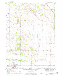
1970 Map of Marengo North
USGS Topo · Published 1977About this map
Marengo and the agricultural lands of northern McHenry County are shown here during a period of infrastructure expansion in the 1970s. The landscape is defined by the Kishwaukee River and its North Branch and South Branch, which carve through the Kishwaukee Valley. This era saw the transition of local rural landmarks, such as the Plum Tree Country Club and the emerging industrial presence of several Gravel Pits.
Find a feature on this map
44 named features on this map. Tap any name to fly to it.
Don’t see what you’re looking for? This feature index may not catch every label — zoom into the map to look around manually.
Map Details
Editions of this 1970 Marengo North Map
2 editions found
Other maps of this area

1925 · Elgin
USGS Topo · 1:62,500

1926 · Mc Henry
USGS Topo · 1:62,500

1932 · Harvard
USGS Topo · 1:48,000

1937 · Harvard
USGS Topo · 1:62,500

1938 · Genoa
USGS Topo · 1:62,500

1940 · Elgin
USGS Topo · 1:62,500

1944 · McHenry
USGS Topo · 1:62,500

1954 · Rockford
USGS Topo · 1:250,000

1955 · Rockford
USGS Topo · 1:250,000

1958 · Rockford
USGS Topo · 1:250,000