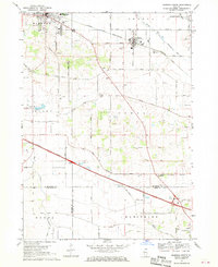
1968 Map of Marengo South
USGS Topo · Published 1970About this map
The southern outskirts of Marengo and the surrounding agricultural townships define this late-1960s landscape, where the Chicago and North Western railroad cuts a diagonal path through the northern half of the quadrangle. The map captures a period of transition as the Northwest Tollway establishes a major modern corridor through the southern half, featuring a Tollgate and proximity to the village of Harmony. Smaller rural centers like Union and Coral anchor the local community, with landmarks such as Union Ch and multiple family-service burial grounds including Union Cem and Coral Cem provided for researchers. The terrain is marked by the winding South Branch Kishwaukee River and numerous gravel extractions, reflecting both the glacial geology and the infrastructure needs of the growing northern Illinois region.
Find a feature on this map
57 named features on this map. Tap any name to fly to it.
Don’t see what you’re looking for? This feature index may not catch every label — zoom into the map to look around manually.
Map Details
Editions of this 1968 Marengo South Map
2 editions found
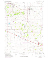
Other maps of this area

1925 · Elgin
USGS Topo · 1:62,500

1926 · Mc Henry
USGS Topo · 1:62,500

1932 · Harvard
USGS Topo · 1:48,000

1937 · Harvard
USGS Topo · 1:62,500

1938 · Genoa
USGS Topo · 1:62,500

1940 · Elgin
USGS Topo · 1:62,500

1944 · McHenry
USGS Topo · 1:62,500

1954 · Rockford
USGS Topo · 1:250,000

1955 · Rockford
USGS Topo · 1:250,000

1958 · Rockford
USGS Topo · 1:250,000