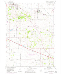
1968 Map of Marengo South
USGS Topo · Published 1977About this map
The Chicago and North Western railway cuts through the northern townships of Seneca and Coral, establishing the early industrial character of this agricultural region. Just south of the tracks, the Railway Museum sits near the village of Union, reflecting the importance of rail history to the area. The landscape is dotted with small-scale rural infrastructure, from numerous Gravel Pits to the Casa de Aero Landing Strip in the south.
Find a feature on this map
51 named features on this map. Tap any name to fly to it.
Don’t see what you’re looking for? This feature index may not catch every label — zoom into the map to look around manually.
Map Details
Editions of this 1968 Marengo South Map
2 editions found
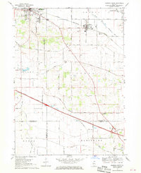
Other maps of this area

1925 · Elgin
USGS Topo · 1:62,500

1926 · Mc Henry
USGS Topo · 1:62,500

1932 · Harvard
USGS Topo · 1:48,000

1937 · Harvard
USGS Topo · 1:62,500

1938 · Genoa
USGS Topo · 1:62,500

1940 · Elgin
USGS Topo · 1:62,500

1944 · McHenry
USGS Topo · 1:62,500

1954 · Rockford
USGS Topo · 1:250,000

1955 · Rockford
USGS Topo · 1:250,000

1958 · Rockford
USGS Topo · 1:250,000