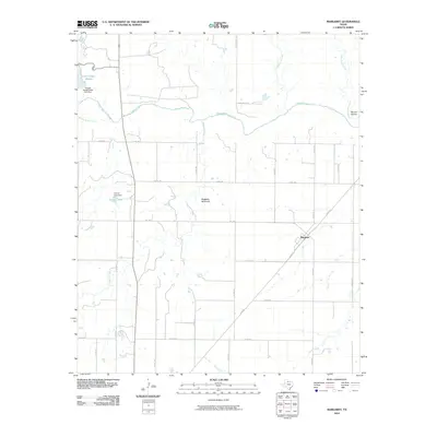
2010 Map of Margaret
USGS Topo · Published 2010About this map
Margaret sits at the junction of N FM 98 and several rural routes in Foard County, serving as the primary settlement in this northern Texas landscape. The terrain is defined by the winding course of the Pease River, which cuts across the northern half of the quadrangle. Significant water management features are evident through the Copper Breaks State Park Dam, which contains Lake Copper Breaks in the northwest, and the Carroll Lake Dam further south. The physical geography of the area is further characterized by prominent landmarks like Raggedy Mountain and Warrior Hollow, providing notable relief against the grid of farm-to-market roads. This map documents a region where ranching and agricultural life are deeply tied to the intermittent flows of Raggedy Creek, Cottonwood Creek, and Mule Creek, illustrating the modern layout of these historic Texas plains.
Find a feature on this map
34 named features on this map. Tap any name to fly to it.
Don’t see what you’re looking for? This feature index may not catch every label — zoom into the map to look around manually.
Map Details
Editions of this 2010 Margaret Map
This is the sole edition of this map. No revisions or reprints were ever made.
Other maps of this area

1927 · Quanah 3-a
USGS Topo · 1:48,000

1932 · Vivian
USGS Topo · 1:62,500

1954 · Wichita Falls
USGS Topo · 1:250,000

1955 · Lawton
USGS Topo · 1:250,000

1958 · Wichita Falls
USGS Topo · 1:250,000

1958 · Medicine Mound
USGS Topo · 1:62,500

1960 · Teacup Mountain
USGS Topo · 1:62,500

1966 · Crowell
USGS Topo · 1:24,000

1966 · Thalia
USGS Topo · 1:24,000
1968 · Foard City
USGS Topo · 1:24,000