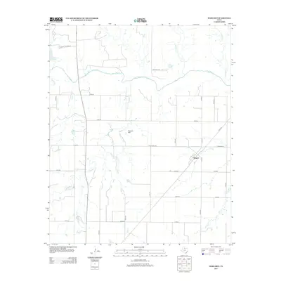
2012 Map of Margaret
USGS Topo · Published 2012About this map
The Pease River meanders across this Foard County landscape, defining a region where water and topography dictate the layout of roads and ranchland. The settlement of Margaret sits at the junction of several local routes, including Ranch Road 3103 and Ranch Road 98, serving as a central hub for the surrounding rural territory. Rising to the west of the town, Raggedy Mtn provides a distinct landmark overlooking the drainage basins of Raggedy Cr and Mule Cr. To the northwest, Lake Copper Breaks and Carroll Lake indicate the importance of water management in this part of Texas. The map reveals a grid of county roads, such as Co Rd-246 and Co Rd-214, that partition the land between the breaks of the river and the various creek branches including Cottonwood Cr and Hackberry Cr.
Find a feature on this map
32 named features on this map. Tap any name to fly to it.
Don’t see what you’re looking for? This feature index may not catch every label — zoom into the map to look around manually.
Map Details
Editions of this 2012 Margaret Map
This is the sole edition of this map. No revisions or reprints were ever made.
Other maps of this area

1927 · Quanah 3-a
USGS Topo · 1:48,000

1932 · Vivian
USGS Topo · 1:62,500

1954 · Wichita Falls
USGS Topo · 1:250,000

1955 · Lawton
USGS Topo · 1:250,000

1958 · Wichita Falls
USGS Topo · 1:250,000

1958 · Medicine Mound
USGS Topo · 1:62,500

1960 · Teacup Mountain
USGS Topo · 1:62,500

1966 · Crowell
USGS Topo · 1:24,000

1966 · Thalia
USGS Topo · 1:24,000
1968 · Foard City
USGS Topo · 1:24,000