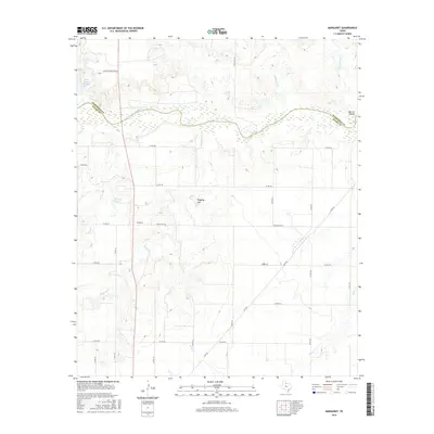
2016 Map of Margaret
USGS Topo · Published 2016About this map
The Pease River defines the northern boundary of Foard County in this part of North Texas, carving a wide, braided path through the landscape. The small community of Margaret serves as a central point in an area dominated by cattle ranching and rural agriculture, reflected in the extensive network of county roads like Ranch Rd 3103 and N FM 98. Distinctive landforms such as Raggedy Mtn and Warrior Hollow provide notable elevation changes in an otherwise steady terrain of creek drainages. Hydrology is a prominent feature of the quadrangle, with Carroll Lake and the southeastern corner of Lake Copper Breaks providing essential water resources. These bodies of water, along with named tributaries like Raggedy Cr and Hackberry Cr, illustrate the critical relationship between water management and land use in this semi-arid region.
Find a feature on this map
35 named features on this map. Tap any name to fly to it.
Don’t see what you’re looking for? This feature index may not catch every label — zoom into the map to look around manually.
Map Details
Editions of this 2016 Margaret Map
This is the sole edition of this map. No revisions or reprints were ever made.
Other maps of this area

1927 · Quanah 3-a
USGS Topo · 1:48,000

1932 · Vivian
USGS Topo · 1:62,500

1954 · Wichita Falls
USGS Topo · 1:250,000

1955 · Lawton
USGS Topo · 1:250,000

1958 · Wichita Falls
USGS Topo · 1:250,000

1958 · Medicine Mound
USGS Topo · 1:62,500

1960 · Teacup Mountain
USGS Topo · 1:62,500

1966 · Crowell
USGS Topo · 1:24,000

1966 · Thalia
USGS Topo · 1:24,000
1968 · Foard City
USGS Topo · 1:24,000