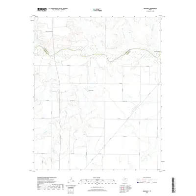
2019 Map of Margaret
USGS Topo · Published 2019About this map
The Pease River carves a wide, braided path across this North Texas landscape, defining the jagged border between Hardeman and Foard counties. This terrain is characterized by its complex drainage network, where multiple seasonal streams like Raggedy Cr and Mule Cr feed toward the river valley. Significant landmarks rise above the drainage basins, notably the prominent Raggedy Mtn and the recessed Warrior Hollow in the northeast.
Find a feature on this map
32 named features on this map. Tap any name to fly to it.
Don’t see what you’re looking for? This feature index may not catch every label — zoom into the map to look around manually.
Map Details
Editions of this 2019 Margaret Map
This is the sole edition of this map. No revisions or reprints were ever made.
Other maps of this area

1927 · Quanah 3-a
USGS Topo · 1:48,000

1932 · Vivian
USGS Topo · 1:62,500

1954 · Wichita Falls
USGS Topo · 1:250,000

1955 · Lawton
USGS Topo · 1:250,000

1958 · Wichita Falls
USGS Topo · 1:250,000

1958 · Medicine Mound
USGS Topo · 1:62,500

1960 · Teacup Mountain
USGS Topo · 1:62,500

1966 · Crowell
USGS Topo · 1:24,000

1966 · Thalia
USGS Topo · 1:24,000
1968 · Foard City
USGS Topo · 1:24,000