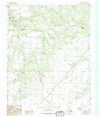
1990 Map of Margaret
USGS Topo · Published 1995About this map
The Margaret settlement serves as the focal point of this North Texas survey, situated just south of the Pease River near the border of Hardeman and Foard counties. The landscape is defined by the drainage patterns of Raggedy Creek, Hackberry Creek, and Mule Creek, which carve through the plains toward the river valley. To the northwest, the colorful breaks of the Copper Breaks State Park highlight the region's unique geology, while Raggedy Mountain provides a distinct topographic landmark. Evidence of local industry and infrastructure is visible in the presence of Grain Bins, a Gravel Pit, and a protective Levee, reflecting the agricultural and resource-based economy of this rural landscape during the late twentieth century.
Find a feature on this map
14 named features on this map. Tap any name to fly to it.
Don’t see what you’re looking for? This feature index may not catch every label — zoom into the map to look around manually.
Map Details
Editions of this 1990 Margaret Map
This is the sole edition of this map. No revisions or reprints were ever made.
Other maps of this area

1927 · Quanah 3-a
USGS Topo · 1:48,000

1932 · Vivian
USGS Topo · 1:62,500

1954 · Wichita Falls
USGS Topo · 1:250,000

1955 · Lawton
USGS Topo · 1:250,000

1958 · Wichita Falls
USGS Topo · 1:250,000

1958 · Medicine Mound
USGS Topo · 1:62,500

1960 · Teacup Mountain
USGS Topo · 1:62,500

1966 · Crowell
USGS Topo · 1:24,000

1966 · Thalia
USGS Topo · 1:24,000
1968 · Foard City
USGS Topo · 1:24,000