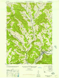
1946 Map of Margaretville
USGS Topo · Published 1946About this map
The East Branch Delaware River flows through the heart of this mid-century landscape, carving a valley where the village of Margaretville serves as a primary hub. At this time, the settlement at Dunraven and the community of New Kingston to the north are connected by a network of hollows—including Sanford Hollow, Weaver Hollow, and Thompson Hollow—each defined by small brooks and farm-to-market roads. The terrain is marked by steep climbs to Mount Pisgah and Pakatakan Mtn, illustrating the difficult mountain topography of the Catskill State Park boundary.
Find a feature on this map
36 named features on this map. Tap any name to fly to it.
Don’t see what you’re looking for? This feature index may not catch every label — zoom into the map to look around manually.
Map Details
Editions of this 1946 Margaretville Map
This is the sole edition of this map. No revisions or reprints were ever made.
Other maps of this area

1901 · Margaretville
USGS Topo · 1:62,500

1904 · Hobart
USGS Topo · 1:62,500

1904 · Margaretville
USGS Topo · 1:62,500

1909 · Delhi
USGS Topo · 1:62,500

1911 · Delhi
USGS Topo · 1:62,500

1922 · Andes
USGS Topo · 1:62,500

1924 · Andes
USGS Topo · 1:62,500

1943 · Bloomville
USGS Topo · 1:24,000
1945 · Seager
USGS Topo · 1:24,000

1945 · Fleischmanns
USGS Topo · 1:24,000