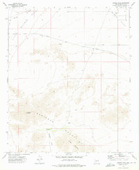
1973 Map of Margies Peak
USGS Topo · Published 1975About this map
Maricopa Mountains dominate this arid landscape, rising sharply from the floor of Rainbow Valley and Little Rainbow Valley. The terrain is characterized by intricate desert drainage systems, notably Rainbow Wash, and steep summits including Margies Peak and Sheep Mountain. Water sources in this high-heat environment are sparse, marked by man-made infrastructure like the CCC Tank, Hazen Tank, and the seasonally unreliable Mountain Well (Dry). A singular Prospect on the northern slopes of the range points to the region's history of mineral exploration. Transport and utility corridors are minimal, consisting primarily of Riggs Road, a Private Pipeline, and several Jeep Trails that skirt the base of the mountains and lead into the sheltered Margies Cove.
Find a feature on this map
15 named features on this map. Tap any name to fly to it.
Don’t see what you’re looking for? This feature index may not catch every label — zoom into the map to look around manually.
Map Details
Editions of this 1973 Margies Peak Map
2 editions found
Other maps of this area

1946 · Avondale
USGS Topo · 1:62,500

1948 · Cashion
USGS Topo · 1:62,500

1951 · Mobile
USGS Topo · 1:62,500

1951 · Cotton Center
USGS Topo · 1:62,500

1954 · Phoenix
USGS Topo · 1:250,000

1957 · Phoenix
USGS Topo · 1:250,000

1957 · Avondale SW
USGS Topo · 1:24,000

1958 · Phoenix
USGS Topo · 1:250,000

1958 · Hassayampa
USGS Topo · 1:24,000

1958 · Buckeye
USGS Topo · 1:24,000