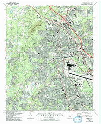
1992 Map of Marietta
USGS Topo · Published 1992About this map
Kennesaw Mountain National Battlefield Park dominates the western landscape of this early 1990s survey, preserving the civil war terrain of Kennesaw Mountain, Pigeon Hill, and Cheatham Hill. The map documents a period of significant suburban intensification between Marietta and Smyrna, where dense residential street grids and commercial corridors surround institutional landmarks like the Southern Tech Institute and the Chiropractic College.
Find a feature on this map
69 named features on this map. Tap any name to fly to it.
Don’t see what you’re looking for? This feature index may not catch every label — zoom into the map to look around manually.
Map Details
Editions of this 1992 Marietta Map
2 editions found
Other maps of this area

1888 · Atlanta
USGS Topo · 1:125,000

1890 · Suwanee
USGS Topo · 1:125,000

1890 · Cartersville
USGS Topo · 1:125,000

1890 · Atlanta
USGS Topo · 1:125,000

1891 · Marietta
USGS Topo · 1:125,000

1891 · Cartersville
USGS Topo · 1:125,000

1892 · Atlanta
USGS Topo · 1:125,000

1894 · Suwanee
USGS Topo · 1:125,000

1895 · Atlanta
USGS Topo · 1:125,000

1895 · Marietta
USGS Topo · 1:125,000