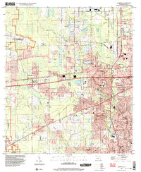
1994 Map of Marietta
USGS Topo · Published 2003About this map
Military installations and suburban expansion define this portion of Duval County during the mid-1990s. The landscape is anchored by the U.S. Naval Reservation Olf Whitehouse and a section of U.S. Naval Reservation (Cecil Field), while civil aviation is represented by Herlong Airport. These facilities sit alongside established communities such as Marietta and Whitehouse, where the network of the Old Plank Road and Gainesville Road facilitates movement through the low-lying terrain of Bulls Bay.
Find a feature on this map
69 named features on this map. Tap any name to fly to it.
Don’t see what you’re looking for? This feature index may not catch every label — zoom into the map to look around manually.
Map Details
Editions of this 1994 Marietta Map
This is the sole edition of this map. No revisions or reprints were ever made.
Other maps of this area

1917 · Orange Park
USGS Topo · 1:62,500

1917 · Cambon
USGS Topo · 1:62,500

1918 · Middleburg
USGS Topo · 1:62,500

1918 · Cambon
USGS Topo · 1:62,500

1918 · Jacksonville
USGS Topo · 1:62,500

1918 · Orange Park
USGS Topo · 1:62,500

1941 · Middleburg
USGS Topo · 1:62,500

1948 · Jacksonville
USGS Topo · 1:250,000

1949 · Fiftone
USGS Topo · 1:24,000

1949 · Jacksonville Heights
USGS Topo · 1:24,000
Featured Places
- Jacksonville, FL
- Hart Haven, Jacksonville
- Whitehouse, Jacksonville
- Caleb, Jacksonville
- Normandy Village, Jacksonville