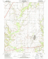
1991 Map of Marine
USGS Topo · Published 1991About this map
Marine serves as the focal point of this Madison County survey, illustrating a landscape defined by its agricultural roots and the shifting infrastructure of the late twentieth century. The town is situated near Neudeckers Mountain, with the surrounding countryside dotted by small family and community cemeteries such as Wood Cem, Seybert Cem, and Randall Cem. The rural fabric is further defined by historic religious sites like Immanuel Ch and small clusters at Kaufman and Fruit.
Find a feature on this map
47 named features on this map. Tap any name to fly to it.
Don’t see what you’re looking for? This feature index may not catch every label — zoom into the map to look around manually.
Map Details
Editions of this 1991 Marine Map
This is the sole edition of this map. No revisions or reprints were ever made.
Other maps of this area

1906 · Breese
USGS Topo · 1:62,500

1907 · Breese
USGS Topo · 1:62,500

1907 · Belleville
USGS Topo · 1:62,500

1927 · Edwardsville
USGS Topo · 1:62,500

1932 · Edwardsville
USGS Topo · 1:62,500

1937 · Collinsville
USGS Topo · 1:24,000

1937 · New Douglas
USGS Topo · 1:48,000

1944 · New Douglas
USGS Topo · 1:62,500

1949 · St. Jacob
USGS Topo · 1:24,000

1950 · Edwardsville
USGS Topo · 1:24,000