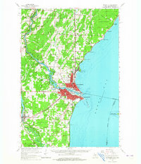
1963 Map of Marinette
USGS Topo · Published 1965About this map
Menominee River serves as the focal point for industrial and civic life on the Michigan-Wisconsin border during the mid-1960s, separating the twin cities of Menominee and Marinette. The landscape reveals a complex network of transportation and education, featuring the Chicago and North Western and Chicago Milwaukee St Paul and Pacific railroads that serviced the waterfront. Local institutions like the County Teachers College and St Marys Mission anchor the community's social history. Beyond the urban centers, the terrain transitions into timber and agricultural lands, dotted with small rural schools such as Hansen Sch and Winesville Sch. Along the shore of Green Bay, notable maritime features including Seagull Bar and Juttner Point define the coast, while Green Island sits further out in the bay. Farther south, the Peshtigo River winds through the Peshtigo area toward its mouth at Peshtigo Harbor.
Find a feature on this map
74 named features on this map. Tap any name to fly to it.
Don’t see what you’re looking for? This feature index may not catch every label — zoom into the map to look around manually.
Map Details
Editions of this 1963 Marinette Map
This is the sole edition of this map. No revisions or reprints were ever made.
Other maps of this area

1939 · Marinette
USGS Topo · 1:48,000

1939 · Porterfield
USGS Topo · 1:48,000

1942 · Porterfield
USGS Topo · 1:48,000

1942 · Wausaukee
USGS Topo · 1:48,000

1947 · Wausaukee
USGS Topo · 1:48,000

1949 · Stephenson
USGS Topo · 1:48,000

1954 · Escanaba
USGS Topo · 1:250,000

1954 · Manitowoc
USGS Topo · 1:250,000

1956 · Oconto
USGS Topo · 1:62,500

1957 · Escanaba
USGS Topo · 1:250,000