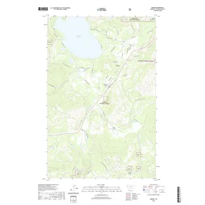
2020 Map of Marion
USGS Topo · Published 2020About this map
Little Bitterroot Lake dominates the northern reaches of this Flathead County landscape, where the settlement of Marion serves as a local hub near the eastern shore. The terrain transitions from the water's edge into the Salish Mountains, much of which is managed as part of the Flathead National Forest. This modern survey reveals a complex network of forest roads and residential drives such as Bitterroot Estates Dr and Marion Pines Dr, illustrating the contemporary residential growth surrounding the lake. South of the main settlement, the Little Bitterroot River flows through a valley marked by Cabin Creek Landing and the Hanson Airport. Further into the forest, more isolated features like Skookum Lake, Hidden Lakes, and the marshy expanse of Granger Meadow highlight the area's hydrology and land use patterns.
Find a feature on this map
49 named features on this map. Tap any name to fly to it.
Don’t see what you’re looking for? This feature index may not catch every label — zoom into the map to look around manually.
Map Details
Editions of this 2020 Marion Map
This is the sole edition of this map. No revisions or reprints were ever made.
Other maps of this area
1956 · Wallace
USGS Topo · 1:250,000
1957 · Kalispell
USGS Topo · 1:250,000
1960 · Kalispell
USGS Topo · 1:250,000
1960 · Wallace
USGS Topo · 1:250,000
1961 · Kalispell
USGS Topo · 1:250,000
1964 · Lone Lake
USGS Topo · 1:24,000
1964 · Haskill Mountain
USGS Topo · 1:24,000
1964 · Kofford Ridge
USGS Topo · 1:24,000
1964 · Pleasant Valley Mountain
USGS Topo · 1:24,000
1964 · Hubbart Reservoir
USGS Topo · 1:24,000