
1970 Map of Marion NE
USGS Topo · Published 1973About this map
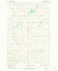
Glacial depressions and prairie wetlands define this landscape along the border of Barnes and La Moure counties. The survey depicts a predominantly rural expanse organized into historic townships like Greenland, Rosebud, and S V E A, reflecting the area's agricultural settlement patterns. In the southern portion of the sheet, the Burlington Northern railroad tracks cross the flatlands near Sheridan and Prairie, illustrating the vital transportation corridor for North Dakota grain. Evidence of the local community's heritage is found at the Swedish Cem and Bethlehem Cem, while the presence of a Gravel Pit indicates small-scale resource extraction. Large water bodies such as Meadow Lake break up the section lines, highlighting the importance of natural drainage in this northern plains environment during the early 1970s.
Find a feature on this map
11 named features on this map. Tap any name to fly to it.
Don’t see what you’re looking for? This feature index may not catch every label — zoom into the map to look around manually.
Map Details
Editions of this 1970 Marion NE Map
This is the sole edition of this map. No revisions or reprints were ever made.
Other maps of this area

1897 · Eckelson
USGS Topo · 1:125,000

1952 · Dickey
USGS Topo · 1:24,000

1953 · Jamestown
USGS Topo · 1:250,000

1956 · Jamestown
USGS Topo · 1:250,000

1970 · Litchville
USGS Topo · 1:24,000
1970 · Litchville SW
USGS Topo · 1:24,000
1970 · Moon Lake
USGS Topo · 1:24,000
1970 · Marion NW
USGS Topo · 1:24,000
1970 · Eckelson SE
USGS Topo · 1:24,000
1970 · Eckelson SW
USGS Topo · 1:24,000
Featured Places
- Svea Township, ND
- Prairie Township, ND
- Sheridan Township, ND
- Rosebud Township, ND
- Greenland Township, ND