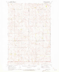
1970 Map of Marion NW
USGS Topo · Published 1973About this map
The intersection of Stutsman, Barnes, and La Moure counties in the early 1970s reveals a vast prairie landscape organized by township boundaries. In the township of Greenland, the North Marion Ch and an adjacent Cem serve as the primary landmarks in an otherwise rural agricultural expanse. The topography is defined by numerous depressions and small water bodies typical of the region, interspersed with several Gravel Pit locations that indicate local industry and road building. This survey captures the rural character of southeastern North Dakota, where large township blocks like Ypsilanti, Meadow Lake, and Manns dictate the social and geographic layout of the land. Fine dashed lines on the map denote selected fence and field lines as they appeared during aerial photography in 1969, providing a high level of detail for those tracing historical property boundaries or family land holdings.
Find a feature on this map
14 named features on this map. Tap any name to fly to it.
Don’t see what you’re looking for? This feature index may not catch every label — zoom into the map to look around manually.
Map Details
Editions of this 1970 Marion NW Map
This is the sole edition of this map. No revisions or reprints were ever made.
Other maps of this area

1896 · Jamestown
USGS Topo · 1:125,000

1897 · Eckelson
USGS Topo · 1:125,000

1952 · Ypsilanti
USGS Topo · 1:24,000

1952 · Dickey
USGS Topo · 1:24,000

1953 · Jamestown
USGS Topo · 1:250,000

1953 · Montpelier
USGS Topo · 1:24,000

1953 · Adrian
USGS Topo · 1:24,000

1956 · Jamestown
USGS Topo · 1:250,000

1970 · Marion NE
USGS Topo · 1:24,000
1970 · Eckelson SE
USGS Topo · 1:24,000
Featured Places
- Saratoga Township, ND
- Sheridan Township, ND
- Greenland Township, ND
- Meadow Lake Township, ND
- Stutsman County, ND