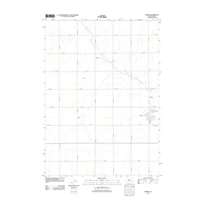
2012 Map of Marion
USGS Topo · Published 2012About this map
The W Fork Vermillion River snakes through the heart of Turner County, providing the primary topographical relief to an otherwise orderly landscape of section-line roads. This survey reveals a community deeply rooted in its local history, evidenced by the numerous cemeteries that dot the landscape surrounding the settlement of Marion. From Saint Marys Cem on the northern edge to Greenwood Cem in the south, these sites offer valuable touchstones for genealogical research. The street grid of the town itself is well-defined, with thoroughfares like S Broadway Ave and Florida Ave establishing the residential and commercial core. Rural transit is facilitated by an extensive network of numbered roads, including 274th St and 444th Ave, which connect isolated landmarks such as West Vermillion Cem and Tieszen Cem to the regional center.
Find a feature on this map
25 named features on this map. Tap any name to fly to it.
Don’t see what you’re looking for? This feature index may not catch every label — zoom into the map to look around manually.
Map Details
Editions of this 2012 Marion Map
This is the sole edition of this map. No revisions or reprints were ever made.
Other maps of this area

1898 · Parker
USGS Topo · 1:125,000

1955 · Sioux Falls
USGS Topo · 1:250,000

1958 · Sioux Falls
USGS Topo · 1:250,000

1964 · Canistota
USGS Topo · 1:24,000

1964 · Bridgewater East
USGS Topo · 1:24,000

1964 · East Vermillion Lake
USGS Topo · 1:24,000

1968 · Parker SW
USGS Topo · 1:24,000
1968 · Parker
USGS Topo · 1:24,000

1970 · Freeman SE
USGS Topo · 1:24,000
1970 · Freeman
USGS Topo · 1:24,000