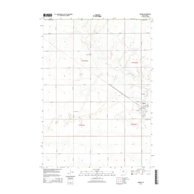
2015 Map of Marion
USGS Topo · Published 2015About this map
The town of Marion serves as the primary hub in this portion of Turner County, where the street grid meets the agricultural section lines of the South Dakota prairie. The landscape is defined by the winding course of the West Fork Vermillion River, which snakes across the northern and central townships. For those tracing family histories, the map identifies several local burial grounds that mark the heritage of early settler families and religious congregations, including West Vermillion Cem and Tieszen Cem. In the village itself, streets such as Florida St and S Main Ave frame the local community. The distribution of these landmarks, alongside Dicks Cem and Saint Marys Cem, reflects a deeply rooted rural settlement pattern that has persisted into the early 21st century.
Find a feature on this map
35 named features on this map. Tap any name to fly to it.
Don’t see what you’re looking for? This feature index may not catch every label — zoom into the map to look around manually.
Map Details
Editions of this 2015 Marion Map
This is the sole edition of this map. No revisions or reprints were ever made.
Other maps of this area

1898 · Parker
USGS Topo · 1:125,000

1955 · Sioux Falls
USGS Topo · 1:250,000

1958 · Sioux Falls
USGS Topo · 1:250,000

1964 · Canistota
USGS Topo · 1:24,000

1964 · Bridgewater East
USGS Topo · 1:24,000

1964 · East Vermillion Lake
USGS Topo · 1:24,000

1968 · Parker SW
USGS Topo · 1:24,000
1968 · Parker
USGS Topo · 1:24,000

1970 · Freeman SE
USGS Topo · 1:24,000
1970 · Freeman
USGS Topo · 1:24,000