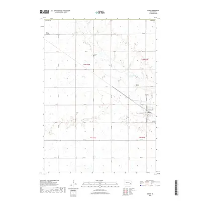
2017 Map of Marion
USGS Topo · Published 2017About this map
Marion serves as the primary hub in this portion of Turner County, South Dakota, situated in a landscape defined by the winding course of the West Fork Vermillion River. The settlement pattern follows a rigid section-line grid, typical of the Great Plains, with roads like 273rd St and 444th Ave carving the prairie into productive agricultural blocks. A remarkable number of small burial sites are scattered throughout these townships, suggesting a deep-rooted community history and the legacy of early homesteading families. From the Our Lady of Lourdes Catholic Cem in the northwest to the Greenwood Cem near the eastern town limits, these sites anchor the map with genealogical significance. In the heart of the town, streets such as N Broadway Ave and W Florida St denote the local center of commerce and residence alongside the river's drainage basin.
Find a feature on this map
38 named features on this map. Tap any name to fly to it.
Don’t see what you’re looking for? This feature index may not catch every label — zoom into the map to look around manually.
Map Details
Editions of this 2017 Marion Map
This is the sole edition of this map. No revisions or reprints were ever made.
Other maps of this area

1898 · Parker
USGS Topo · 1:125,000

1955 · Sioux Falls
USGS Topo · 1:250,000

1958 · Sioux Falls
USGS Topo · 1:250,000

1964 · Canistota
USGS Topo · 1:24,000

1964 · Bridgewater East
USGS Topo · 1:24,000

1964 · East Vermillion Lake
USGS Topo · 1:24,000

1968 · Parker SW
USGS Topo · 1:24,000
1968 · Parker
USGS Topo · 1:24,000

1970 · Freeman SE
USGS Topo · 1:24,000
1970 · Freeman
USGS Topo · 1:24,000