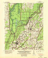
1941 Map of Marked Tree
USGS Topo · Published 1954About this map
The St Francis Sunk Lands dominate this Arkansas landscape, where the St Francis River and its intricate distributaries defined the development of Poinsett County and its neighbors. By the early 1940s, a complex system of ditches and levees attempted to manage the wetlands, yet much of the area remained defined by island-like landforms such as Coon Island and Middle Island. The settlement at Marked Tree sits at the confluence of the river and the St Louis - San Francisco Ry, serving as a critical hub for the local timber and agricultural economy.
Find a feature on this map
65 named features on this map. Tap any name to fly to it.
Don’t see what you’re looking for? This feature index may not catch every label — zoom into the map to look around manually.
Map Details
Editions of this 1941 Marked Tree Map
2 editions found
Other maps of this area

1931 · Jericho
USGS Topo · 1:62,500

1939 · Jericho
USGS Topo · 1:62,500

1939 · Jonesboro
USGS Topo · 1:62,500

1939 · Evadale
USGS Topo · 1:62,500

1940 · Deckerville
USGS Topo · 1:62,500

1940 · Princedale
USGS Topo · 1:62,500

1940 · Dee
USGS Topo · 1:62,500

1941 · Leachville
USGS Topo · 1:62,500

1941 · Manila
USGS Topo · 1:62,500

1941 · Marked Tree
USGS Topo · 1:62,500