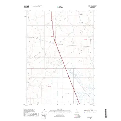
2020 Map of Market Lake
USGS Topo · Published 2020About this map
Sage Junction serves as a critical point on this high-desert landscape in Jefferson County, where the intersection of major transit routes and water management infrastructure defines the local geography. The map reveals an intricate network of irrigation, featuring the Robison Canal and Bell Larsen Canal, which divert water to support agriculture in an otherwise arid environment. This irrigation system feeds toward the seasonally wet basin of the Market Lake "Slough" in the southeastern portion of the quadrangle. North of the junction, the small settlement of Hawgood sits along the rail corridor, while the distinctive topographic rise of Mollys Nipple provides a notable natural landmark to the west. The presence of Old Hwy 91 running parallel to the modern interstate and rail lines highlights the historical evolution of travel through this corridor of eastern Idaho.
Find a feature on this map
22 named features on this map. Tap any name to fly to it.
Don’t see what you’re looking for? This feature index may not catch every label — zoom into the map to look around manually.
Map Details
Editions of this 2020 Market Lake Map
This is the sole edition of this map. No revisions or reprints were ever made.
Other maps of this area

1948 · Lewisville
USGS Topo · 1:24,000

1949 · Lewisville
USGS Topo · 1:24,000

1949 · Roberts
USGS Topo · 1:62,500

1949 · Roberts
USGS Topo · 1:24,000

1950 · Roberts
USGS Topo · 1:24,000

1955 · Idaho Falls
USGS Topo · 1:250,000

1958 · Idaho Falls
USGS Topo · 1:250,000

1964 · Kettle Butte NE
USGS Topo · 1:24,000
1964 · Market Lake
USGS Topo · 1:24,000
1964 · Deer Parks
USGS Topo · 1:24,000